Lidar based V2X communication solution to improve road safety
In many countries, governments do view Vehicle to Everything (V2X) technology as offering great promise to help reduce road fatalities. V2X is an umbrella term for a vehicle’s wireless communication system, where information from sensors and other data sources is shared via high-bandwidth communication.
Much of the early V2X focus has been on communication between vehicles to exchange information that can help determine the risk of crashes so drivers can take early evasive actions, as needed. To fully realize the safety benefits of V2X, this communication needs to extend beyond vehicles to include infrastructure and pedestrians using the same roadways. In doing so, V2X can provide the critical data needed to improve traffic and protect vulnerable road users.
Where are we now with V2X and where do we want to go in future?
Recently the automotive industry has been working to improve ADAS (Advanced Driving Assistance System) functionality for consumer vehicles. From a sensor perspective, ADAS enhancement can be achieved by sensor-fusion for redundancy and with robust algorithms for object recognition, object tracking, and provision of decision paths derived from this.
Car manufacturers around the world have multiple approaches in choosing the right combination of sensors, including lidar, radar and camera. There is also an increasing focus on how to not only make vehicles smarter, but also transform the infrastructure to be “smart.” Technologies like lidar, which delivers accurate, real-time 3D data, are a key component in new systems to advance safety and efficiency in cities. With new technology, critical scenarios can be monitored and tracked, from near misses to collisions. Even improved ADAS – such as ADAS level 2 – might react too late to prevent them. By providing key data about intersections and public spaces, cities can work to prevent collisions and other traffic incidents.
DSRC vs. Cellular-V2X
V2X communication is used to establish a communication between multiple different road users where V2X enabled vehicles are acting as the communication hub. Currently, there are two V2X standards – Dedicated Short Range Communication (DSRC) and Cellular-V2X.
DSRC is based on semi-passive transponder technology, establishing direct vehicle-to-vehicle communication in short distances (~1km drive by sight, ~300m in case of sight obscuration). DSRC is a tailored communication for on-road vehicles using standard IEEE 802.11p. To be prepared to meet growing demand on speed and amount of data transfer, Cellular-V2X has a wider utility zone as it is based on LTE & 5G communication. to be prepared to meet also growing demand on speed and amount of data transfer and criteria for different device platforms in future.
Both DSRC and Cellular-V2X have already been adopted into serial production cars which reached the market recently: 2015 for DSRC and 2021 for Cellular-V2X. DSRC is the most common technology because it has been developed and deployed more extensively.
Car manufacturers are designing both standards to work inside one single software hardware stack. This approach enables a vehicle to be operated in different regions around the globe with different preferences for V2X standards. The interface enables new features or supports improvements in existing vehicles like collision protection (V2V – Vehicle to Vehicle) and Emergency Vehicle Approaching (V2V). It also supports Lane Departure Warning System (V2R – Vehicle to Road), Intersection Assistant (V2I – Vehicle to Infrastructure) and Road Works Warning (V2I), and many more.
DSRC does have limitations, which means the IEEE 802.11p standard must catch up with the development speed of new upcoming features and performance. Cyber security hurdles exist for both standards, and a way to resolve these issues is to deploy a security solution which embeds itself in V2X chipsets. This protects the V2X system with both authentication and data encryption technologies.
Making vehicles “smart” is only half the solution
Let’s look at a typical edge case of ADAS in an urban driving situation. One example is occlusion due to other vehicles, diverse infrastructure components or buildings which limit the view of a vehicle. This is one of the numerous potential use cases where lidar-enhanced traffic monitoring solutions can help to improve road safety. Lidar provides a precise 3D map of its environment, which can minimize occlusion by delivering real-time data for safe navigation.
Another scenario to consider is in a crowded intersection with multiple road users involved. A vehicle equipped with current ADAS features may not be able to detect and identify obstacles. It is important to enhance vehicle safety features in complex traffic situations. Communication between today’s state of the art DSRC-equipped vehicles could address collision protection or approaching emergency vehicles. However, these communication platforms may exclude pedestrians and other road users not equipped with DSRC nor Cellular-V2X capabilities. Without these tools road users would not be “recognized” by other DSRC/Cellular-V2X-equipped vehicles sending warning signals about upcoming risks. A critical consideration is how to cover road users that do not belong to a working network system or are falling through the DSRC net.
There is a pressing need to solve this problem, which brings the focus to the infrastructure. A lidar-based traffic monitoring system is needed, providing real-time data and warning signals to affected vehicles. The system needs to be robust under different environmental conditions and communicate on the same Cellular-V2X network as vehicles.
Lidar as a key enabler sensor technology for smart cities
Lidar manufacturers and municipal governments are increasingly recognizing big future potential benefits that can be gained with ITS (Intelligent Transport Systems). Lidar technology has advantages where other sensor types like cameras and radar might come up short in these applications.
Optical cameras are dependent on environmental lighting conditions, where lidar is its own light source. Different system designs of lidar can be helpful in selecting the right sensor or a combination of sensors for specific use cases in infrastructure projects. These include solid state lidar with a defined FoV (Field of View) and rotational lidar with a 360° horizontal FoV and a fixed vertical FoV.
In terms of different weather conditions, such as rain, snow and fog, lidar can detect participants in road traffic as representing small road users. Lidar recognizes its surroundings as a point cloud, where all collected data points deliver a specific distance and timestamp. Algorithms inside post-processing units — understanding typical patterns of obstacles — enable a complete object recognition and tracking solution with an object list. For example, that list could contain pedestrians, bicycles, e-scooters, passenger cars, buses and heavy-duty vehicles. This output data can be used to fulfill multiple specific safety and traffic management needs.
Let’s come back to the edge case of a “smart” vehicle communicating to just other “smart” vehicles. How will lidar-based IIS improve road safety, if there are multiple road users not belonging to the same network system where the vehicles are? As stated before, classification and tracking based on a pattern recognition algorithm are the key enablers. Lidar can provide maximum distance detection as well as minimum vertical and horizontal resolution. These affect the recognition and tracking distance of objects. A stationary 32-channel 3D-lidar sensor and a Velodyne IIS edge computing box combination, for example, are able to classify road users like pedestrians within a radius of 50m or more. Limitation in how many objects a system can track is settled by the software algorithm to understand multiple different patterns at same time. Covering convoluted areas or blind spots for traffic flow, a lidar edge box solution can predict a potentially risky situation by analyzing the trajectory of multiple road users and send Cellular-V2X warning signals to one or multiple vehicles in question.
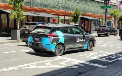
Fig.1 shows a lidar surveillance system with an edge computing unit, in connection with an RSU (Roadside Unit). This setup sends the location of pedestrians and cyclists to connected vehicles.
Fig. 2 shows a snapshot of a connected car that has received notification of approaching cyclists via the C-V2X protocol. The top snapshot shows the notification while the cyclist is out of the driver’s line of sight. The snapshot below is two seconds after the cyclists approached the intersection.


Let’s examine the advantage to primarily use lidar instead of other sensor technologies for object recognition and tracking. Can’t an optical camera do the job as well?
Cameras represent one of the most commonly used sensor technologies in the automotive industry and in public security. The technology has been established for many years now, getting increasingly reasonable in terms of cost, and easy to maintain. It has been tested in terms of robustness to meet diverse customer’s requirements.
There are several answers for this question about optical camera’s performance. Lidar is independent from environmental conditions. A V2X infrastructure system to improve road safety must be fully operational 24/7. It has to be robust in detection and operation, in continuously changing environmental conditions, such as day and night lighting, streetlights, backlights, snow, rain, fog and more.
The sensor needs to be adaptive to meet multiple different mounting conditions and observe traffic situations – ideally off-the-shelf with low calibration efforts. The capabilities of multi-object recognition and tracking distance and trajectory with high accuracy are also required to establish a precise warning network in highly frequented urban areas. The sensor should ideally be GDPR (General Data Protection Regulation) compliant, including not identifying individuals’ facial characteristics, an important privacy factor. Considering all those points, lidar technology fits the bill best among available sensors.

Conclusion
While on highways, stable working autonomous driving level 2 capabilities can bring significant improvement to safety. However, in urban areas, risk warning systems need to deal with higher complexities. Widely implementing DSRC in passenger vehicles will bring improvements, but the key is Cellular-V2X to enable real-time LTE and 5G communication between vehicle and infrastructure.
Velodyne’s lidar-equipped Intelligent Infrastructure Solution will bring the next level of safety improvement, performing real-time risk measurements to warn drivers about upcoming issues from urban blind spots. In doing so, it will move V2X forward in tackling one of the most challenging and pervasive infrastructure problems that cities face – how to improve traffic flows and safeguard road users. Smart infrastructure integrated with connected and autonomous vehicles have the potential to deliver game-changing improvements in roadway efficiency and safety. They can help create a more sustainable, safer future for transportation.
Alexander Montag | Sr. Field Applications Engineer – EMEA Velodyne Europe
Image sources: By courtesy of Bluecity Technology and Velodyne Lidar